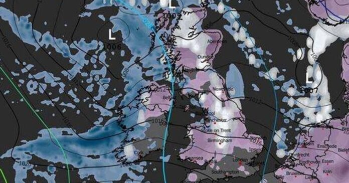
The United Kingdom is bracing for extreme weather conditions with forecasts showing blizzards extending as far south as London and Birmingham, with one area expected to receive up to 25 inches of snow.
Anticipated snowfall, set to arrive imminently, will cover one region with 65cm (25 inches) of snow today. According to WXCharts maps based on MetDesk data, temperatures are projected to drop to a bone-chilling -11C in parts of Scotland as a cold front moves across the country.
In the meantime, the Met Office has issued multiple yellow warnings for ice and snow affecting various regions. Monday saw the implementation of four yellow alerts, with an additional five weather warnings announced for today by the Met Office.
The National Weather Agency has cautioned that the snow and icy conditions could lead to travel disruptions, and some areas might face power outages due to the severe weather conditions. WXCHARTS maps indicate that areas around Inverness, Dundee, Aberdeen, and Glasgow will experience heavy snowfall on Tuesday, with the Northern Highlands and the Isle of Skye expected to be buried under 65cm of snow.
By 6 am on Tuesday, snowfall is predicted to reach parts of England, including London, Birmingham, Manchester, Stoke on Trent, and Newcastle. The weather maps suggest that by Tuesday evening, even regions around Southampton, Bristol, Plymouth, and Cornwall will be covered in snow.
The Met Office’s forecast for Tuesday, January 6, anticipates wintry showers in parts of Wales and southwest England at the start of the day, with a mix of rain, sleet, and snow moving southeastwards across Scotland and Northern Ireland, eventually reaching Wales and England later on.
Moreover, the Met Office has warned of potentially disruptive snowfall affecting central and northern Scotland from late Tuesday morning until early evening. Matthew Lehnert, Chief Meteorologist at the Met Office, emphasized the likelihood of various winter weather hazards persisting throughout the week, including low temperatures, snow showers, and the risk of ice.
Looking ahead to the upcoming week, the Met Office forecasts a continuation of cold weather with frontal systems approaching from the west, bringing a mixture of rain, sleet, and snow across the country at intervals, accompanied by strong winds.
In the long-range forecast spanning Saturday through Monday, January 19, the Met Office predicts a changeable period with Atlantic frontal systems periodically affecting the UK, resulting in rain, potentially preceded by snow in some areas, especially in northern and eastern regions. There is a possibility of significant snowfall, particularly in northern hills, alongside intermittent strong winds and periods of frost. After a cold start, temperatures are expected to gradually approach average levels, with the potential for a temporary return to drier and colder conditions towards the end of the forecast period.
