
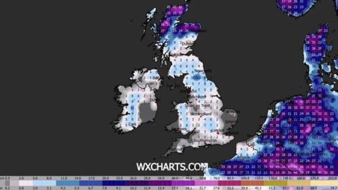

Britain is facing the possibility of a severe winter blast, with heavy snowfall and freezing temperatures expected in just over a week, according to new weather forecasts. The latest predictions by forecaster WXCharts suggest that by Saturday, January 10, large parts of the UK could be covered in snow, with depths of up to 42cm in the worst-affected areas and temperatures dropping as low as -12C.
Snow depth models indicate that the most extreme conditions are anticipated in Scotland, particularly the Highlands, where widespread snow totals of 30 to 40cm are forecasted, with even higher amounts over elevated areas. Northern regions of England, including the Pennines and North York Moors, are also likely to see significant snowfall, with accumulations ranging from 10cm to 20cm.
In areas just south of Newcastle, snow depths of 9cm to 12cm are expected. Moving further south, parts of the Midlands and southern England may see a layer of snow, albeit in lower quantities of one to five centimetres, with higher totals over hills in Wales and southwest England.
Northern Ireland is also set to witness snowfall, with potential accumulations of five to 10cm in some places. Alongside the snow, temperature charts indicate a severe Arctic blast in the forecast.
Forecasts for minimum temperatures at 6am on January 10, compiled on December 31, suggest that large regions of the UK will experience temperatures well below freezing, with expected lows of -7C to -12C across inland Scotland and northern England. Even southern areas, including Wales, London, and the South East, could see temperatures dropping to -2C to -4C, raising the risk of widespread ice formation. While long-term forecasts are subject to change, if these projections hold true, parts of the UK could be preparing for one of the harshest and most snow-filled periods of the winter so far, resembling conditions more typical of a deep continental freeze than a standard British January.
Meanwhile, the latest long-range forecast from the Met Office covering January 5 to January 14 indicates: “Cold northerly winds will dominate across the UK in the initial week of January, bringing wintry showers, often of snow, to many exposed coastlines and inland areas. Moving into the following week, more organized bands of precipitation and thicker cloud could approach from the west, potentially leading to further snowfall transitioning to rain. The return to a milder Atlantic flow is uncertain, with a possibility of additional cold airflows following fronts, resulting in wintry showers, especially in northern UK regions.
Temperatures are expected to recover to slightly below average for most areas, with colder conditions more likely in the north at times.”
The Met Office advises caution regarding its longer-term forecasts, stating: “When looking beyond five days ahead, the unpredictable nature of the atmosphere can have significant impacts on UK weather from small events currently occurring over the Atlantic.”