
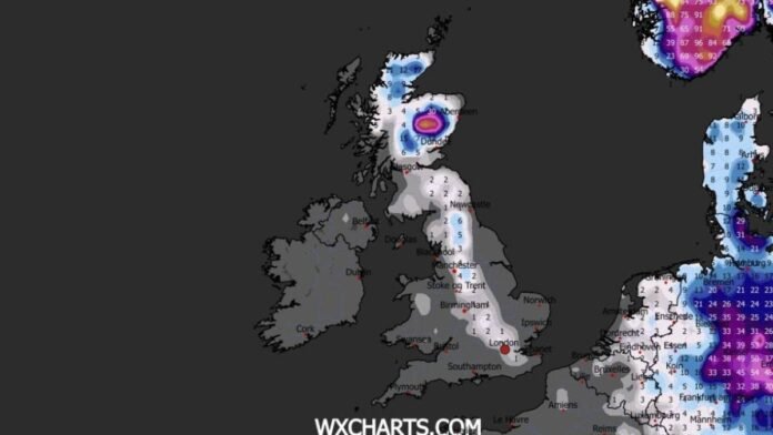

Weather maps are displaying a cold, icy blue hue as Britain prepares for a significant drop in temperatures and widespread snowfall that is expected to cover almost the entire country. New predictions from WX Charts suggest snow accumulations exceeding 40cm (15.7 inches) in central Scotland, with a substantial band of snow forecasted to move through the Pennines and reach as far south as Kent by midday on February 12.
Scotland is likely to see a heavy snowfall, while England may experience lighter accumulations ranging from 3-6cm (1.2-2.4 inches) based on WX Charts’ maps generated on January 31. The same date is expected to bring extremely cold conditions, with temperatures plummeting well below freezing in Scotland (between -3C and -9C) and England (ranging from 0C to -5C) according to separate WX Charts data.
Cities like Aberdeen, Newcastle, and Hull could potentially see temperatures dropping to -7C, -4C, and -2C respectively if current forecasts hold true. Looking ahead, WX Charts’ projections suggest that Atlantic rain systems will move in during the first half of the next month, potentially bringing snow to various areas. However, precise predictions for dates beyond February 12 remain uncertain.
The Met Office highlights the challenges of accurately forecasting snow in Britain due to its island geography and the influence of sea temperatures on whether precipitation falls as rain or snow. The latest 10-day outlook from the Met Office indicates that low-pressure systems driven by the jet stream will bring further rainfall to Britain, potentially turning into snow as colder air masses move in.
For the period of February 5-14, the Met Office forecasts bands of rain moving northwards that could transition into snow on higher ground in England and Scotland. There is a possibility of a shift southwards of low-pressure areas during the second week of February, increasing the likelihood of colder air spreading across northern UK and bringing wintry conditions.
Netweather’s long-range outlook suggests that snow is probable on elevated terrain, and occasionally at lower levels as well, with a focus on an area stretching from southern Scotland through north Wales to the Midlands. Northern Scotland is expected to experience sunshine, snow showers, and snow accumulations on lower ground for much of the week starting February 9.
In summary, the weather in Britain is set to turn colder with widespread snowfall anticipated across various regions, as indicated by recent weather forecasts.