

Britons are being advised to prepare by stocking up on food, water, and flashlights as up to a meter of snow is forecasted to fall within the next few days.
The weather forecast for the first half of February indicates wintry conditions, with the Met Office issuing yellow weather warnings for snow as temperatures are anticipated to drop to -4°C.
Low-pressure systems moving in from the Atlantic Ocean are combining with cold Arctic air, resulting in snow showers. The national weather agency has issued a snow warning covering northern and central Scotland from midnight tonight until 3 p.m. on Wednesday. Additionally, a warning is in effect for the Shetland Islands from 6 p.m. tomorrow until midnight on Wednesday.
Residents in the affected areas of Scotland are urged to plan ahead and, if driving, to pack essentials such as food, water, and flashlights.
The Met Office advises, “Snowy and wintry weather conditions may cause travel delays and hazardous driving conditions. Ensure your safety and that of others by planning your journey, allowing extra time, and checking for road closures or public transport disruptions. Have essential items in your car in case of delays, including warm clothing, food, water, a blanket, a flashlight, ice scraper/de-icer, a warning triangle, high-visibility vest, and an in-car phone charger.”
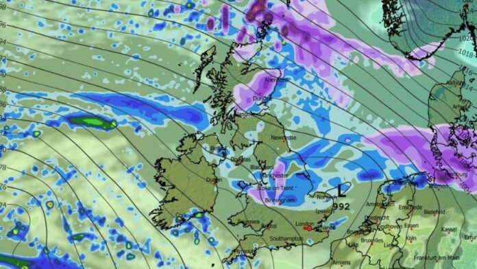
Weather maps from WXCharts indicate snowfall in Scotland, northern England, and Wales on Wednesday. Temperatures are expected to drop to -4°C in the north and hover around zero degrees across the country, with central Scotland likely to receive over a meter of snow by midday Wednesday.
The Met Office’s yellow warning for central and northern Scotland, including the Orkney Islands, states, “Rain transitioning into sleet and then snow is expected to affect eastern and northern Scotland from Tuesday into Wednesday. Accumulations of 1-3 cm are likely above 100 meters, possibly up to 5 cm in some areas. At elevations above 200 meters, snow accumulations of 10 cm are expected, with localized totals of up to 20 cm. Lower elevations may experience a mix of rain, sleet, and snow, leading to light snow cover in some areas. Strong winds may cause blizzard conditions and snow drifting, particularly in the northern part of the warning area.”
A separate warning for the Shetland Islands warns of blizzards and drifting snow, with persistent snowfall expected from Tuesday evening through Wednesday, potentially causing disruptions. Accumulations of 1-3 cm are forecasted widely, with higher ground possibly receiving 5-10 cm. Strong winds could lead to blizzard conditions and snow drifting.
Areas affected by the weather warnings include Central, Tayside & Fife, Grampian, Highlands & Eilean Siar, Orkney & Shetland, and Strathclyde.