
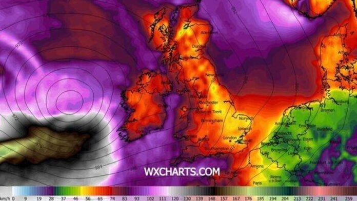

The United Kingdom is preparing for a harsh winter as new weather maps indicate a significant Atlantic storm heading towards the country, bringing snow, heavy rain, and strong winds. The forecast charts, generated by WXCharts, show the storm approaching from the Atlantic on January 27 at 6pm. The maps depict widespread snowfall across various regions of the UK, with areas like Scotland, Northern Ireland, northern England, and parts of the Midlands covered in snow, especially in elevated areas. Meanwhile, Wales, central and southern England, including London and the South East, are expected to experience heavy rain along with sporadic wintry showers.
A second map for the same time frame shows that powerful winds are on the way, with coastal areas of Ireland, western Scotland, and northwest England facing gusts exceeding 100mph. Much of England and Wales are forecasted to experience strong winds ranging from 70mph to 90mph, with the potential for even higher speeds of up to 110mph over the Atlantic.
Despite the widespread impact of the storm, only around 10 counties, mainly in southwest England and west Wales, are projected to remain relatively unaffected by the extreme weather conditions, avoiding substantial rain or snowfall.
The Met Office’s long-range forecast covering January 24 to February 2 suggests that the UK will continue to be influenced by Atlantic weather systems, resulting in periods of heavy rain or showers, particularly in the south and west regions. While milder conditions may occur in the south and west intermittently, colder weather is expected, increasing the likelihood of snow, especially in Scotland and northern England.
Looking ahead, the Met Office advises caution when interpreting forecasts beyond five days, as minor atmospheric events over the Atlantic can have significant impacts on the weather in the UK and Ireland days later.