
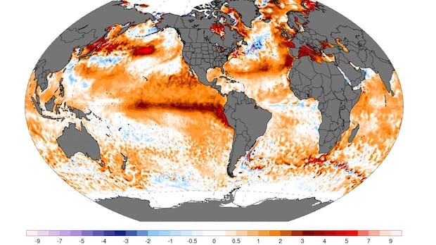

The highly anticipated El Niño has arrived, and it is proving to be as predicted. Climate experts had foreseen the development of an El Niño in the central Pacific earlier this year. Over time, models increasingly indicated the likelihood of a strong or “super” El Niño, though it was cautioned that certainty was premature.
In its update in June, the U.S. National Oceanic and Atmospheric Administration (NOAA) confirmed the presence of warmer conditions in the specific Niño 3.4 region of the Pacific Ocean, meeting the criteria for an El Niño where temperatures need to exceed 0.5°C above average. Current ocean temperatures are nearly 2°C above average, marking a record high for this time of year.
According to Zeke Hausfather, a climate scientist with Berkeley Earth, the region is already experiencing El Niño conditions, with temperatures surpassing 2°C, indicating a very strong or “super” El Niño. Forecasts suggest the El Niño may peak in October, although some models lean towards November or December for the peak.
El Niño is part of the natural cycle known as the El Niño Southern Oscillation (ENSO), affecting the Pacific Ocean. In contrast, La Niña brings cooler temperatures to the region. The rapid transition from La Niña to El Niño has been noted by experts, with the current El Niño potentially surpassing past records by a significant margin.
The possibility of this extreme El Niño event has raised questions about its connection to climate change. While shifts in the Niño 3.4 region have been observed, the role of climate change remains uncertain. Potential impacts of the El Niño include food security concerns in tropical regions due to expected droughts and milder but drier conditions in Canada, posing risks for wildfires in Western Canada.
In summary, the current El Niño event is significant and could have far-reaching consequences, emphasizing the need for preparedness and vigilance across various sectors.